Floods in York By Dennis Steel
02nd February 2024
In: Short Stories, News
York Floods
(Written and illustrated by Dennis Steel)
The attached picture of the river Ouse in full flood mode was taken from the centre of the Ouse Bridge, looking down river to the Skeldegate Bridge. This is the highest level of the River Ouse that I have seen for some years and it was flowing at a good rate of knots.
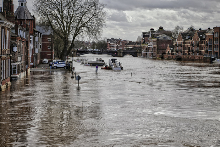
The flooding of the river Ouse is a regular occurrence in the city of York, throughout the year. For the people who live along the river’s edge, the Council has erected flood barriers in their front gardens to help protect them. Their garden gates are prefabricated steel with appropriate heavy seals.
The Kings Arms at Kings Staith, a famous pub, gets flooded out on a regular basis. The landlord has designed the interior to give a quick turn around after flooding. The beer cellar is upstairs and the beer pipes come down to the bar. The downstairs bar is sealed like a swinging pool, so it’s a matter of a good wash down of all surface areas and he is back in business. The landlord takes the opportunity to hold “flood Parties” when the water is starting to rise. So you can stand at the bar in your wellies ankle deep in water enjoying a pint of Sam Smiths beer. That is an unique experience!
The worst aspect of the York flooding is the mud, (4” to 6” thick), that it is left on the riverside pavements and the St George's Car Park. The council cleans it up, but it’s not really clean until we have a couple of good down-pours of rain. Then it becomes walkable.
The river Ouse is the 6th longest river in the UK. it rises in the central Pennines, combines with the Swale and Ure rivers, then joins the Ouse on its way down to York. It continues via Selby, Goole and finally joins the Humber.
The pictures were taken using my Leica CL with 60 mm APO-Macro f2.8 lens fitted. (Equivalent to 90 mm on full-frame).
Copyright © Dennis Steel 2024
Comments
 By Ken Davis: What a terrifying sight Dennis, this certainly records very effectively the effect our race is having on the planet. The Kings Arms landlord has adapted at a cost! By David Askham: The grey sky and cold swirling water makes a very dramatic city landscape, Dennis. Your picture of an adventurous child adds a very human element to the unwelcome recurring scene. By Cled Lewis: The shots of the river in flood bring back memories of our time in Yorkshire. You really have to see the reality of the scene to appreciate the power of the river but Dennis’ conveys that frightening atmosphere to perfection.
The little girl with her fascination for the water gives a completely different impression.
By Ken Davis: What a terrifying sight Dennis, this certainly records very effectively the effect our race is having on the planet. The Kings Arms landlord has adapted at a cost! By David Askham: The grey sky and cold swirling water makes a very dramatic city landscape, Dennis. Your picture of an adventurous child adds a very human element to the unwelcome recurring scene. By Cled Lewis: The shots of the river in flood bring back memories of our time in Yorkshire. You really have to see the reality of the scene to appreciate the power of the river but Dennis’ conveys that frightening atmosphere to perfection.
The little girl with her fascination for the water gives a completely different impression.