St Aldhelm's Head - Keith Walker
25th July 2025
In: News, Members' Articles
St. Aldhelm’s (or St.Albans) Head - Keith Walker
St. Aldhelm’s Head is a prominent headland of shear cliff west of Swanage on the Dorset Coast.
It sits on the South West Coastal Path, but can also be accessed by a track and walk of just over a mile and a half from a car park in the hamlet of Worth Matravers.
There are several reasons a photographer might visit the Head, which is 108 meters above sea level. Myself and a friend went there to photograph St. Aldhelm’s Chapel, but I came away intrigued by another part of its history.
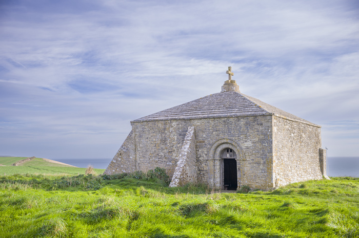
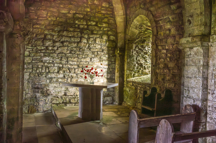
The Chapel is a tiny square building with flying buttress’s and lit inside by a solitary slit window and the open door. It is Norman, and although named Chapel there was originally no alter, so it may have been built as a watchtower. An alter made from stone from a local quarry was added in 2005 as part of the 300 years celebration of
its original consecration. The Chapel first appears in written records during the reign of King Henry III.
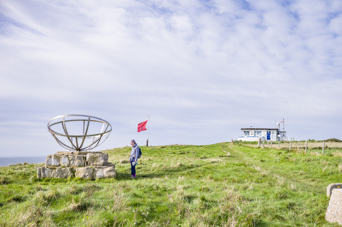
The Chapel shares the site with two other landmarks. First a conventional and active Coastguard look out station, and a monument to the development of radar during WWII. It was this latter item which caught my imagination for further research.
During the War the tiny hamlet of Worth Matravers played host to the building of a research facility that had 2000 people working on the development of radar as a key asset to help win the War. It was staffed by the best in the relevant fields from universities, and many recognised names, like Sir Bernard Lovell, worked there.
To me it is mind blowing that such a large facility, with huge radio masts, could be built so quickly in such a remote location. It also makes one wonder about the security that must have been in place in the area.
There is a very interesting website about the facility for more detailed information:
http://www.purbeckradar.org.uk
St Aldhelm's Head Chapel
St Aldhelm's Head Chapel
Monument To Radar
Some Come To Bird Watch.
St. Aldhelm’s Head is a prominent headland of shear cliff west of Swanage on the Dorset Coast.
It sits on the South West Coastal Path, but can also be accessed by a track and walk of just over a mile and a half from a car park in the hamlet of Worth Matravers.
There are several reasons a photographer might visit the Head, which is 108 meters above sea level. Myself and a friend went there to photograph St. Aldhelm’s Chapel, but I came away intrigued by another part of its history.
The Chapel is a tiny square building with flying buttress’s and lit inside by a solitary slit window and the open door. It is Norman, and although named Chapel there was originally no alter, so it may have been built as a watchtower. An alter made from stone from a local quarry was added in 2005 as part of the 300 years celebration of
its original consecration. The Chapel first appears in written records during the reign of King Henry III.
The Chapel shares the site with two other landmarks. First a conventional and active Coastguard look out station, and a monument to the development of radar during WWII. It was this latter item which caught my imagination for further research.
During the War the tiny hamlet of Worth Matravers played host to the building of a research facility that had 2000 people working on the development of radar as a key asset to help win the War. It was staffed by the best in the relevant fields from universities, and many recognised names, like Sir Bernard Lovell, worked there.
To me it is mind blowing that such a large facility, with huge radio masts, could be built so quickly in such a remote location. It also makes one wonder about the security that must have been in place in the area.
There is a very interesting website about the facility for more detailed information:
http://www.purbeckradar.org.uk
St Aldhelm's Head Chapel
St Aldhelm's Head Chapel
Monument To Radar
Some Come To Bird Watch.
Comments
 By Melinda Stone: Lovely images. The positioning of the altar suggests the Chapel building is not oriented towards the east, which suggests to me that it is unlikely to have been built as a site of worship. It seems remote for a chapel of rest and a bit grand for any hermit, so perhaps you're right it started as a watchtower By David Askham: Ken, thank you for your interesting insight to experimental radar work which was moved inland for safety and security reasons at at early date. However I am not sure that site formed part of Chain Home radar system at the start of WW2. The early receiver towers were made from wood, 220 feet tall, and I doubt any exist today. The transmitter towers were steel and were set on concrete bases. As no remains have been found at the site you visited, I suspect the site was used for other experimental work. I like your interior shot in the chapel with its very natural day lighting. By Keith Walker: Hi David
1. Don't blame Ken, it was my visit
2. One concrete base remains
3. The link posted describes exactly the work that took place there and its "Chain Home' status By Ken Davis: Thanks for the photographs and the information Keith. The development of radar and how we exploited it is akin to the story of Bletchley Park that I posted some weeks ago. They both show how innovative we were, how we exploited such clever minds (some at genius level) and how we out thought the German intelligence services.
By Melinda Stone: Lovely images. The positioning of the altar suggests the Chapel building is not oriented towards the east, which suggests to me that it is unlikely to have been built as a site of worship. It seems remote for a chapel of rest and a bit grand for any hermit, so perhaps you're right it started as a watchtower By David Askham: Ken, thank you for your interesting insight to experimental radar work which was moved inland for safety and security reasons at at early date. However I am not sure that site formed part of Chain Home radar system at the start of WW2. The early receiver towers were made from wood, 220 feet tall, and I doubt any exist today. The transmitter towers were steel and were set on concrete bases. As no remains have been found at the site you visited, I suspect the site was used for other experimental work. I like your interior shot in the chapel with its very natural day lighting. By Keith Walker: Hi David
1. Don't blame Ken, it was my visit
2. One concrete base remains
3. The link posted describes exactly the work that took place there and its "Chain Home' status By Ken Davis: Thanks for the photographs and the information Keith. The development of radar and how we exploited it is akin to the story of Bletchley Park that I posted some weeks ago. They both show how innovative we were, how we exploited such clever minds (some at genius level) and how we out thought the German intelligence services.